
Update — 16 September 2026: VRS X 0.8.2 has been released. This is an archived development preview; the text below describes development at the time. Read the final 0.8.2 release notes →
VRS X v0.8.2 is currently in development.
Unlike most previous devlogs, this page is being published before the release is complete and will be updated as development continues.
The main focus of 0.8.2 is the new weather engine, but the release also brings improvements to route reporting, SVG marker handling, caching, API traffic management and general radar usability.
Some details described below may still change before the final release.
New features
Multi-provider weather engine
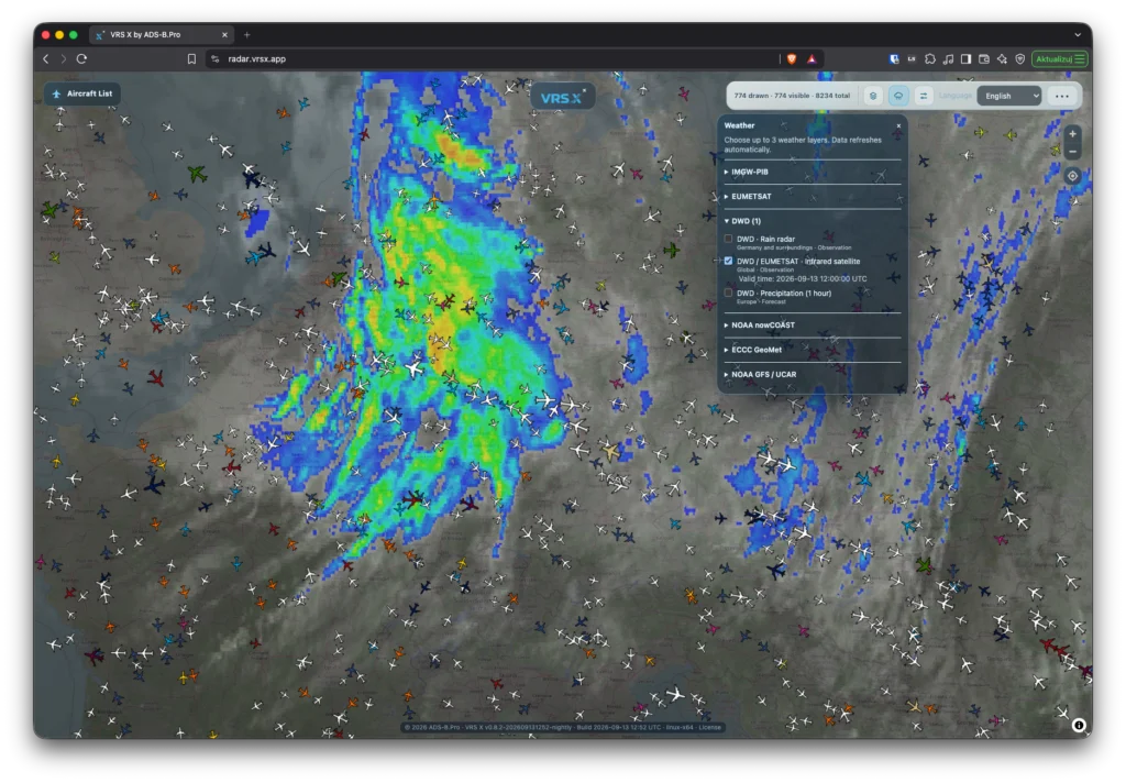
VRS X 0.8.2 significantly expands weather support directly inside the radar.
Weather information is no longer treated as a single data source. The new system is designed around multiple providers and different types of meteorological products, which can be enabled independently from the radar interface.
Current integrations include data and products from:
- DWD
- EUMETSAT
- NOAA nowCOAST
- NOAA GFS / UCAR
- ECCC GeoMet
- IMGW / IMGW-PIB
Depending on the provider, VRS X can display observational, satellite, radar and forecast products directly on the map.
DWD weather layers
DWD support includes several products intended primarily for European coverage.
Currently implemented layers include:
- precipitation radar
- infrared satellite imagery provided through DWD / EUMETSAT
- short-term precipitation forecast products
Weather frames are retrieved automatically and displayed directly on the VRS X radar.
The DWD integration also includes additional handling for edge cases where individual radar tiles cannot be retrieved normally.
EUMETSAT satellite imagery
VRS X can display several EUMETSAT satellite products covering Europe and Africa.
Current products include:
- infrared satellite imagery
- natural colour composition
- air mass composition
These layers provide a broader meteorological overview than precipitation radar alone and allow larger-scale weather systems to be viewed together with live aircraft traffic.
IMGW weather observations
IMGW data is also being integrated into the radar.
The first implemented observational layer displays air temperature from measurement stations directly on the map.
Each observation can include:
- measured temperature
- station name
- observation time
This allows current surface observations to be viewed alongside aircraft traffic and other weather products.
NOAA weather sources
Existing NOAA-based weather support remains part of the new engine and is being integrated into the same provider-based interface.
Sources include:
- NOAA nowCOAST
- NOAA GFS
- UCAR-hosted GFS products
These sources provide additional observational and forecast layers, including wind-related products already supported by VRS X.
ECCC GeoMet
Environment and Climate Change Canada GeoMet is also available as a weather provider.
This gives the weather engine another independent source of meteorological map products and continues the move toward a provider-agnostic weather architecture.
Airport suggestions in route reports
Manual route reporting has been improved with airport search and suggestions.
The FROM, VIA and TO fields can now search for airports after entering at least three characters of an ICAO or IATA code.
The suggestion list:
- displays up to five matching airports
- shows airport codes and names
- supports mouse selection
- supports keyboard navigation
Selecting an airport automatically inserts its ICAO code.
For example:
LHR → EGLL
Airport data is provided by the VRS X Central Database, so a local OurAirports import is not required for this feature.
IATA codes in manual route reports
Users can also enter an IATA airport code directly without selecting a suggestion.
The Central Database validates the value and resolves it to the corresponding ICAO code.
Airport suggestions are therefore a convenience feature rather than a requirement. If suggestions are temporarily unavailable, the route form can still be completed manually.
Bug fixes
Improved imported SVG compatibility
The SVG marker importer has been made more tolerant of valid SVG files created by common graphics editors.
VRS X no longer incorrectly rejects otherwise valid files simply because they contain:
- the standard SVG version attribute
- common editor metadata
- supported safe styling information
Support for safe SVG styling has also been expanded.
Security restrictions remain in place. Scripts, event handlers and disallowed external references continue to be blocked.
Import error messages have also been clarified to make unsupported SVG content easier to diagnose.
Marker catalog cache fix
VRS X 0.8.1 introduced a new SVG-only marker system.
Some upgraded installations could continue using an older cached marker catalog, resulting in generic aircraft markers being displayed instead of the expected silhouettes.
In 0.8.2, the marker catalog URL is now derived from the catalog contents.
When the catalog changes, its URL changes as well, preventing browsers and intermediary caches from continuing to use an outdated version.
Failed catalog downloads are also retried automatically.
DWD radar rendering fix
Some DWD radar tiles near the edge of the available coverage area can fail when requested at the initially selected resolution.
VRS X now detects this case and retries the same geographical area and timestamp using a higher-resolution request.
This allows affected areas to be rendered without simply leaving gaps in the weather layer.
Optimizations & usability
Simplified weather panel
The weather panel has been reorganized around providers.
Weather products are grouped into collapsible sections such as:
- DWD
- EUMETSAT
- NOAA nowCOAST
- ECCC GeoMet
- NOAA GFS / UCAR
- IMGW / IMGW-PIB
This makes the interface easier to navigate as the number of available weather products continues to grow.
The previous time sliders have also been removed.
Users now select a weather layer and VRS X automatically presents the currently selected or most appropriate weather frame.
Collapsing a provider section does not disable its active layers.
Separate API rate limits
Weather traffic can be significantly heavier than normal application API traffic, particularly when radar tiles are being loaded across a large map area.
To prevent weather requests from affecting normal VRS X operation, separate limits are now used.
Current limits are:
- Weather API: 2400 requests per minute
- Other APIs: 600 requests per minute
The radar page also uses a separate rate limit so intensive weather tile loading does not unnecessarily reduce availability of the main interface.
Reduced airport search traffic
Airport autocomplete has been designed to minimize unnecessary requests to the Central Database.
The implementation includes:
- a 300 ms delay after typing before a request is sent
- five-minute result caching
- cancellation of outdated requests
- ignoring responses that arrive after a newer query
- handling of HTTP 429 responses
- support for server-provided retry delays
The Central Database communication token remains entirely on the backend and is never exposed to the browser.
Still under development
VRS X 0.8.2 is not finished yet.
The following weather-related optimizations are currently outside the implemented scope:
- separate download queues for individual weather providers
- coalescing simultaneous requests for the same weather tile
These may be introduced later if required by real-world usage and provider rate limits.
More fixes and improvements may also be added before the final 0.8.2 release.
Release status
VRS X 0.8.2 is currently in active development and testing.
There is no final release date yet.
This devlog will be updated as development progresses.