Update — 16 September 2026: VRS X 0.8.2 has been released. This is an archived development preview; the text below describes development at the time. Read the final 0.8.2 release notes →
VRS X v0.8.2 is still in development.
And yes, it is getting bigger.
Partly because I keep finding things to improve.
Partly because testers keep suggesting things that are unfortunately good ideas.
So if 0.8.2 takes a little longer than originally expected, I would like to officially state that this is clearly your fault. 🙂
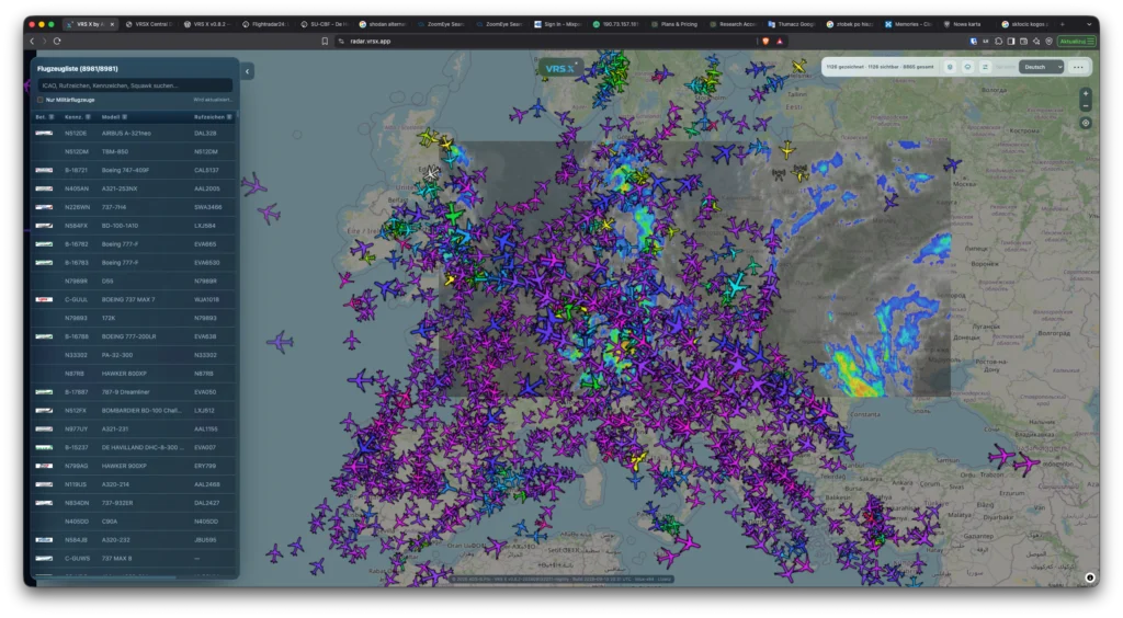
Since the first 0.8.2 development preview, several additional radar features and usability improvements have been implemented.
New features
Aircraft colors by altitude
VRS X can now color aircraft markers according to their current altitude.
This mode is inspired by the altitude coloring used by tar1090, but is implemented as an optional VRS X display mode.
Users can switch between the standard VRS X color logic and altitude-based coloring directly from the radar interface.
When altitude coloring is enabled:
- marker colors are taken from the existing VRS X altitude palette,
- colors update dynamically as aircraft climb or descend,
- standard operator and individual aircraft colors are temporarily overridden.
The existing coloring system remains unchanged when altitude mode is disabled.
This setting is local to the radar user and does not modify server or administrator configuration.
Local marker scaling
Aircraft marker size can now be adjusted directly from the radar interface.
Available range:
0.75x to 2.00x
Adjustment step:
0.05x
Default:
1.00x
The selected scale is applied on top of the existing aircraft-class-based scaling.
This means a C172 remains smaller than a B738, and a B777 or A380 remains proportionally larger, while the user can increase or decrease the overall marker size to suit their screen, resolution or personal preference.
Like altitude coloring, marker scaling is a local display preference and does not affect other users or server configuration.
More flexible aircraft presentation
With the new options, users can now combine:
- SVG aircraft silhouettes,
- aircraft-class-based marker scaling,
- local marker scaling,
- operator colors,
- individual aircraft colors,
- altitude-based colors,
- military aircraft highlighting,
- operator logos.
The goal is to make the radar more flexible without moving personal display preferences into administrator settings.
Weather improvements
DWD integration continues to expand
The DWD provider continues to receive improvements.
Current DWD-related products include:
- precipitation radar,
- short-term precipitation forecast layers,
- DWD / EUMETSAT infrared satellite imagery.
VRS X now handles several edge cases related to DWD tile availability and coverage boundaries more gracefully.
Multi-provider weather engine
The weather engine now brings together several independent data providers:
- DWD,
- EUMETSAT,
- IMGW / IMGW-PIB,
- NOAA nowCOAST,
- NOAA GFS / UCAR,
- ECCC GeoMet.
Depending on the source, VRS X can display:
- precipitation,
- satellite imagery,
- wind,
- forecast products,
- surface observations,
- other meteorological map layers.
Weather providers remain independent from aircraft tracking, so temporary problems with one weather source do not stop the live radar.
Usability
Local preferences remain local
Altitude colors and marker scaling are intentionally stored as local radar preferences.
They are not administrator settings and do not change the server configuration.
Different users viewing the same VRS X installation can therefore configure their radar differently.
Immediate visual updates
Changes to marker scale or color mode are applied immediately to aircraft already visible on the map.
No server restart is required.
Still growing
The current 0.8.2 development branch now includes:
- multi-provider weather engine,
- DWD weather integration,
- EUMETSAT satellite products,
- IMGW surface observations,
- airport autocomplete,
- IATA airport code support,
- improved SVG compatibility,
- marker catalog cache fixes,
- altitude-based aircraft coloring,
- local marker scaling,
- weather and API traffic optimizations.
And yes, more small changes may still appear before release.
Because apparently publishing a development preview was interpreted by some testers as an invitation to send more feature requests.
Thank you very much for that. 🙂
The first v0.8.2 Nightly build is expected soon.